7/1/15: 83 miles, Milford, Ohio, to Sanders, Ky.
We rolled out of Milford on a hot and humid morning. There wasn’t much for showers where we camped, so we did a hobo-bath at the park bathroom across the river. We stopped in Newtown at the United Dairy Farmers (a convenience store in Ohio, Indiana, and Kentucky), which kicks total ass and has ice cream, by the way, and loaded up on food. A few folks came up to John and I asking about our trip. Suzie, a home-care nurse, wished us luck, as well as a guy helping a friend move. “Where’s the motor?” he joked, pointing at our bikes.
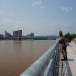
The OTE took us by Cincinnati’s Lunken Airport, and into downtown along the Ohio River. It was a warm Wednesday afternoon, and the Reds were playing an afternoon game. It was bumping downtown.
When I describe the dynamics of Ohio’s cities to people who don’t know Ohio, I usually say that Cleveland and Cincinnati are tough rivals in every sense: politically, economically, culturally, and in sports. But if you ask people from either city what they think about Columbus, they’ll say, “Yeah, it’s pretty cool,” and tell you about their brother or in-laws who live there.
In reality, in almost 30 years, I’ve never really spent much time in Cincinnati. And I have to admit, its riverfront park along the Ohio, as well as the routes in and around town, are the best in Ohio. Columbus’ path network is great, no doubt. But Cincinnati is very hilly, so the skyline is obscured unless you’re downtown or close to it. As I rode into town, the city peeked out and gradually revealed itself from behind hills until it all came together with the river, the bridges, and skyline all against a backdrop of Ohio River Valley hills.
https://instagram.com/p/4mc273xcyc
It took John and I a while to find the entrance to the Purple People Bridge, the pedestrian-only span across the Ohio to Newport, Kentucky. Once we did, we stopped at a bar for a celebratory Rhinegeist beer before beginning what would be a week of climbing in and out of the Ohio River Valley.
The plan now was to follow the Adventure Cycling’s Underground Railroad route to connect with the TransAmerica trail in western Kentucky. But I realized I didn’t have the maps (Shit!) for this section on paper. Luckily it was loaded into my RidewithGPS. I was a bit annoyed that I’d have to stare at my iPhone for the next few days, but it ended up working. We just had to find our own places to stay.
The route:
We made the long slog up and out of Cincinnati and into Kentucky. A few cars honked at us as we remembered what going slow was like. Wound our way through suburbs that gave way to smooth, rolling farmland. What I’d heard about Kentucky was true: the edges of the country and state routes are lined with rumble strips, forcing us further into the road than we’d normally be, and the dogs. We must’ve been chased by about 30 dogs (more on that later).
John and I pushed on to about 8:30 p.m. and made it to Eagle Valley Campground in Sanders. Aside from some RVs already set up for the 4th of July, we were the only people there.
As I set up my camp, a Killdeer bird was squawking at me, doing its fake “I’m dying” kabuki death dance. John explained they do this as an act of self-sacrifice to distract predators from their eggs. I just thought the bird was crazy.
Leave a Reply
You must be logged in to post a comment.