
6/10/15: 68 miles, Hancock, Md., to Cumberland, Md.
Getting out of the Super 8 was slow going. Made a couple pots of coffee and tried to get my shoes and clothes to dry out using the hair dryer after I’d hand washed everything in the sink last night.
In the daylight, I could see where Super 8 motels really shine: water-stained cushion on the chair in the corner, curious brown handprints above the tube TV, and yellowing dog-earned cable channel guide on the nightstand. Again, any port in a storm. I was just glad to be dry, have a roof and bed. Not that your standards go down when you’re bike touring, but you need to be flexible depending on what the road throws as you. I know some people like to stay in nice hotels, but frankly, the motels are key for bike touring, because you don’t need to deal with wheeling your bike through the lobby and screwing around with an elevator. The motels generally have the room door on the exterior of the building, making it easy-in, easy-out. Less hassle, the better.
Ate breakfast from the food in my pack and hit the road around 10. The weather and trail conditions improved. Relief.
The trail gradually become much more Appalachian today, with more exposed rock along the canal and router terrain. I met a group of older folks from England who were credit-card touring (where you carry very little and stay at hotels and B&Bs). The one woman was spreading her husband’s ashes along the trail, with whom she had ridden the C&O years ago—I guess the occasion for the trip.
At one point when I stopped for water, I struck up a conversation with a homeless dude who called himself “Pitiful.” I suspect it wasn’t just a clever name. He said the park service always asked him to leave because he scared park-goers, and lamented the high prices of food in Hancock and Cumberland. I guess when you have nothing, everything is a high price.
Here’s his bike:

The canal meandered away from the Potomac River at one point. That brings us to the first tunnel, the 3,000-ft. Paw Paw tunnel. It was constructed for the canal originally. There is a narrow, pot hole-riddled, railing-lined foot path to ride along, while the stagnant canal claims the majority of the tunnel. When I arrived at the tunnel, a group of guys said the rest of their group was walking through the tunnel. I could see their headlamps poking along the tunnel wall. They made up a group of about eight, coming from Pittsburgh to DC, but I think they were from Richmond. We talked about our trips, tours, bikes, gear, mileage, life, jobs, and I told them about my travelogue. (Hey, guys!)
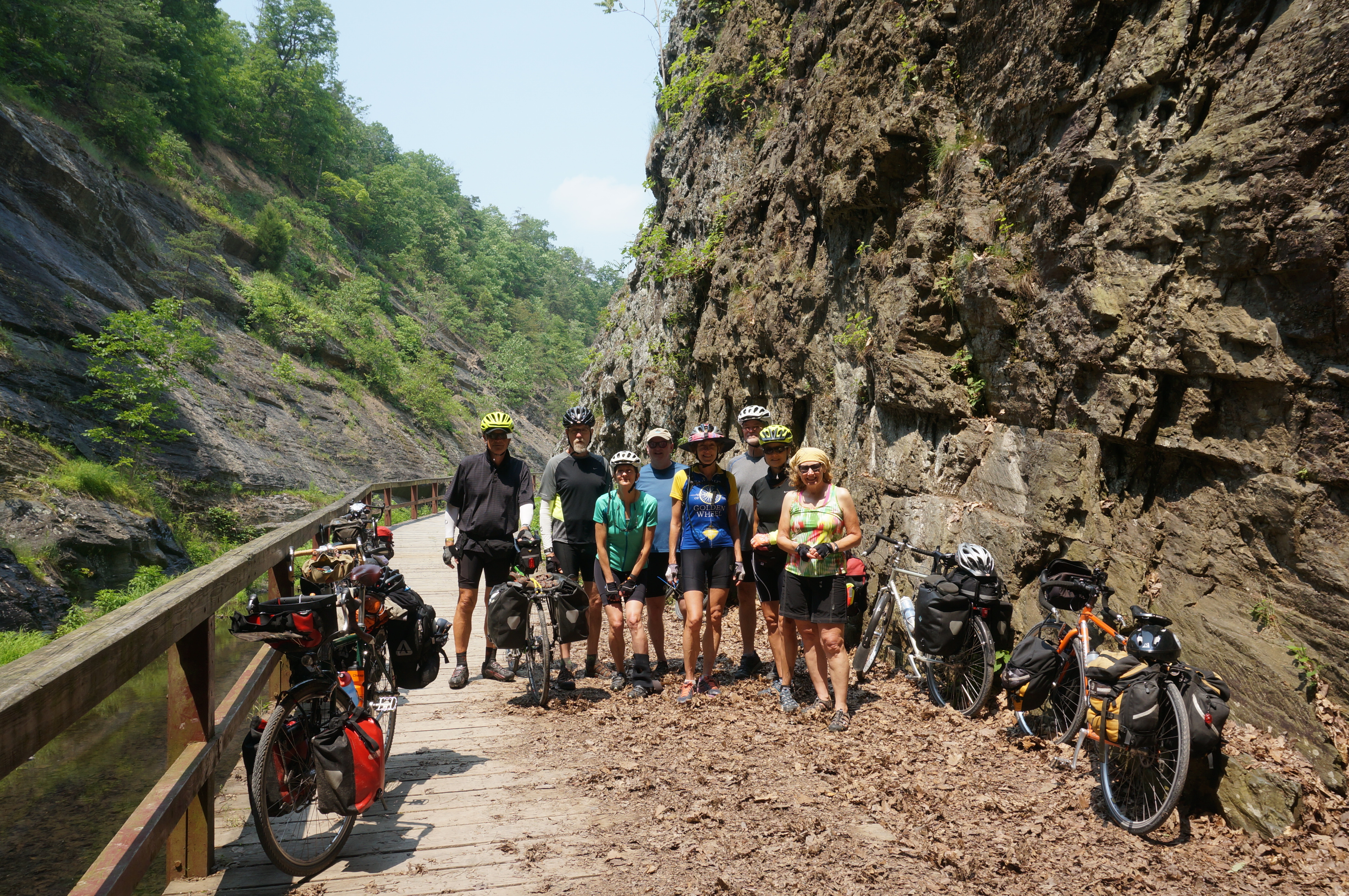
One of the women suggested I should walk through the tunnel, but I assured her I’d ridden it before (I had), and I had lights to illuminate the way. It was bumpy as all hell, not all unlike most of the roads in Chicago or Cleveland I’m accustomed to. You definitely need lights, or you gotta walk. Riding through a dark tunnel with nothing but the light at the end to focus on becomes instantly disorienting. It’s hard to tell if you’re riding straight, left, right, up down—inducing a sort of vertigo that has caused riders to simply lose balance and crash.

As the C&O meanders into Cumberland, Md., the city reveals itself as the surrounding Appalachian hills peel away. It’s a decidedly Appalachian town, though it felt like another outdoor-oriented town. Think Flagstaff. Or Bend. But in Maryland. The path ends at a big trailhead with a bike shop, bar, historical center and all that—even a big arch that makes you want to sprint finish (see top photo). Because it’s also the intersection of the Great Allegheny Passage trail, which runs north from Cumberland to Pittsburgh, the trail head is built up to seamlessly recognize and connect both trail termini.

In my never-end quest for food, I rolled down Baltimore Street. It’s a pedestrian-only brick road that, with restaurants, bars, shops and cafes, appears to be Cumberland’s core. I downed a couple High Lifes and snarfed a crab cake sandwich with onion rings at the Baltimore Street Grill before hitting up a corner store for a night-cap tallboy.
https://instagram.com/p/3z-vIUxc8q/
The nearest campsite was Evitts Creek, which meant I had to backtrack five miles on the C&O. Ah, well. It’s free. And that would give me a few miles to warmup before attacking tomorrow’s 30 mile climb over the Eastern Continental Divide into Pennsylvania.
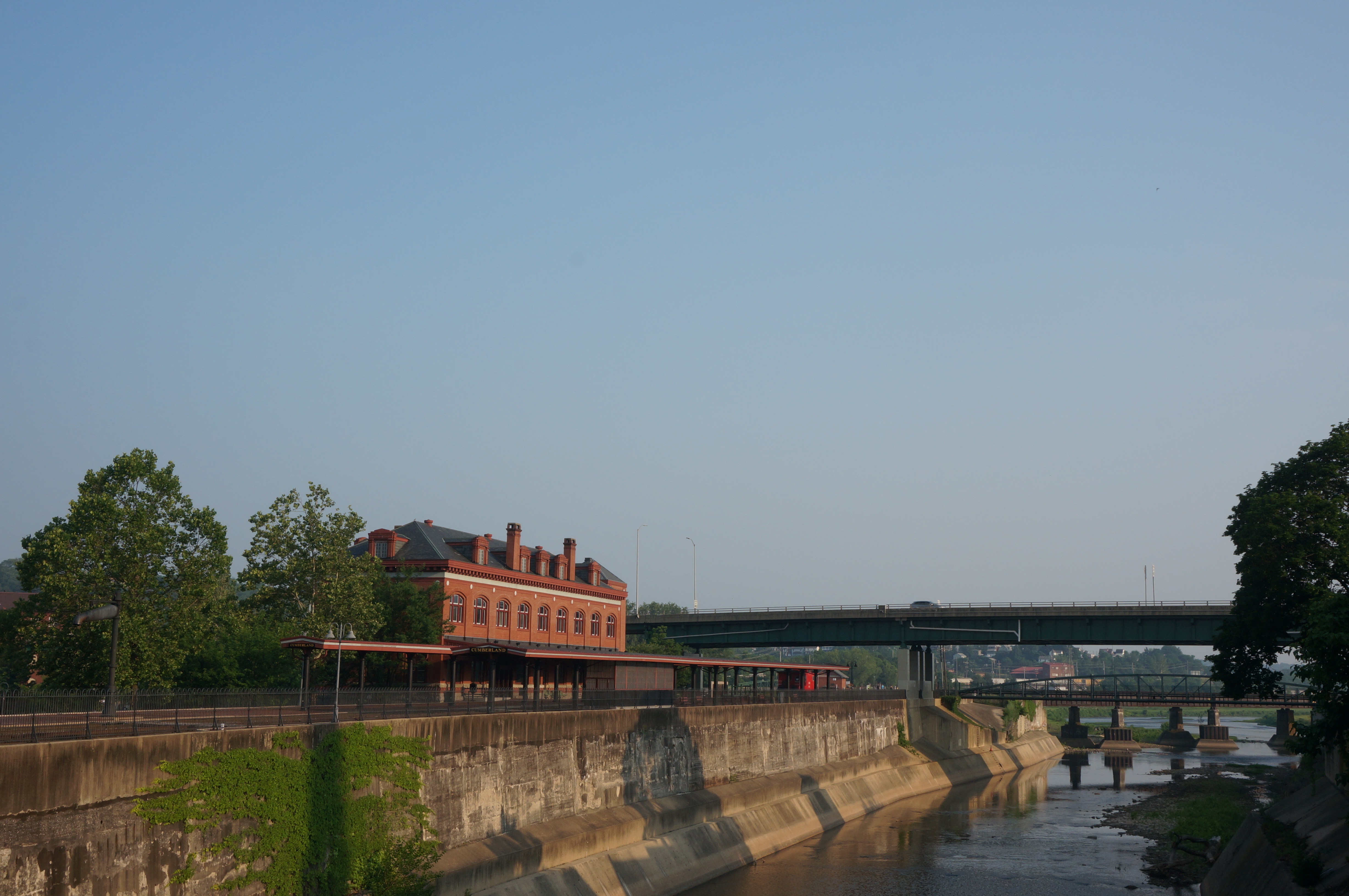
Caught the sunset lighting up the Western Maryland Railway Station on my way out. This building is the landmark junction of the C&O Canal and GAP trails.
Leave a Reply
You must be logged in to post a comment.